- Home
- Corporate Profile
- Forecast
- Earthquake
- Observation
- Climate
- Publication
- Education
- Contact Us
-
Talian Hotline1-300-22-1638
Talian Hotline
1-300-22-1638
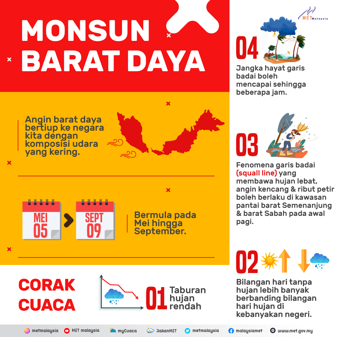
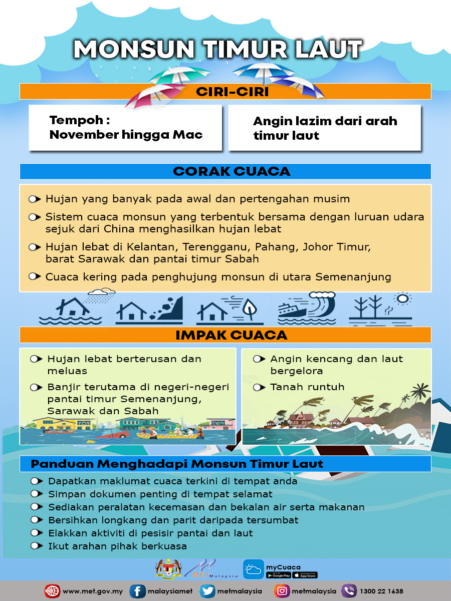
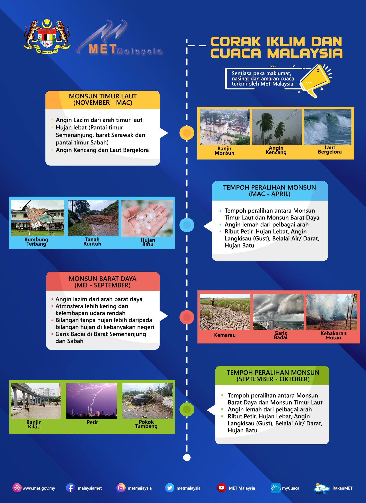
The weather in Malaysia is characterized by two monsoon regimes, namely the Southwest Monsoon that starts from late May to September, and the Northeast Monsoon from November to March. The Northeast Monsoon brings heavy rain especially to the states on the east coast of Peninsular Malaysia, west of Sarawak and east of Sabah, while the Southwest Monsoon relatively shows drier weather. The transition period between these two monsoons is known as the inter-monsoon phase.
The word "monsoon" comes from the Arabic word "musim" which means season. Ancient traders traveling through the Indian Ocean and the Arabian Sea used this word to describe the alternating wind system that blows from the northeast during the winter in the Northern Hemisphere and from the opposite direction, the southwest wind during the summer in the Northern Hemisphere.
Monsoon occurs due to the temperature difference between the land and the ocean as a result of the heating of the sun's rays. During winter, the landmass of the continent cools faster and causes extremely low temperatures in Central Asia. This situation caused the atmospheric pressure to increase and formed a very strong high pressure system (anticyclone) in Siberia. As a result, cold air moves out of Siberia as a northwesterly wind and then turns into a northeasterly wind when it reaches the coastal waters of China before heading to Southeast Asia.
Over time, this strong blast of cold air (monsoon burst) interacts with low pressure systems and cyclonic eddies that form near the Equator, producing strong winds and rough seas in the South China Sea as well as heavy rain on the east coast of Peninsular Malaysia, west of Sarawak and east of Sabah.
In summer, strong solar heating leads to an increase in temperature in mainland Asia. As warm air rises, a partial low-pressure area forms. The moist southeasterly winds originating from the southern Indian Ocean and the Indonesia-Australia region change to southwesterly winds when crossing the Equator. This wind then moves across Southeast Asia before converging towards Indochina, China and the Pacific Northwest.
The Northeast Monsoon season is the main rainy season of our country. The monsoon weather system that forms together with cold air flows from Siberia produces heavy rain that often causes large floods in the east coast states of Kelantan, Terengganu, Pahang and East Johor, as well as the state of Sarawak and Sabah in East Malaysia. The Southwest Monsoon is relatively drier for the entire country except the state of Sabah in East Malaysia. During this season, most states experience minimal monthly rainfall, usually between 100 - 150mm. This situation indicates a stable atmospheric condition in the equatorial region. The dry conditions in Peninsular Malaysia are mainly caused by the rain protection effect of the mountain range in Sumatra. Sabah is relatively wetter (over 200mm) as a result of the tail effects of typhoons that frequently cross the Philippines on their way across the South China Sea and its surroundings.
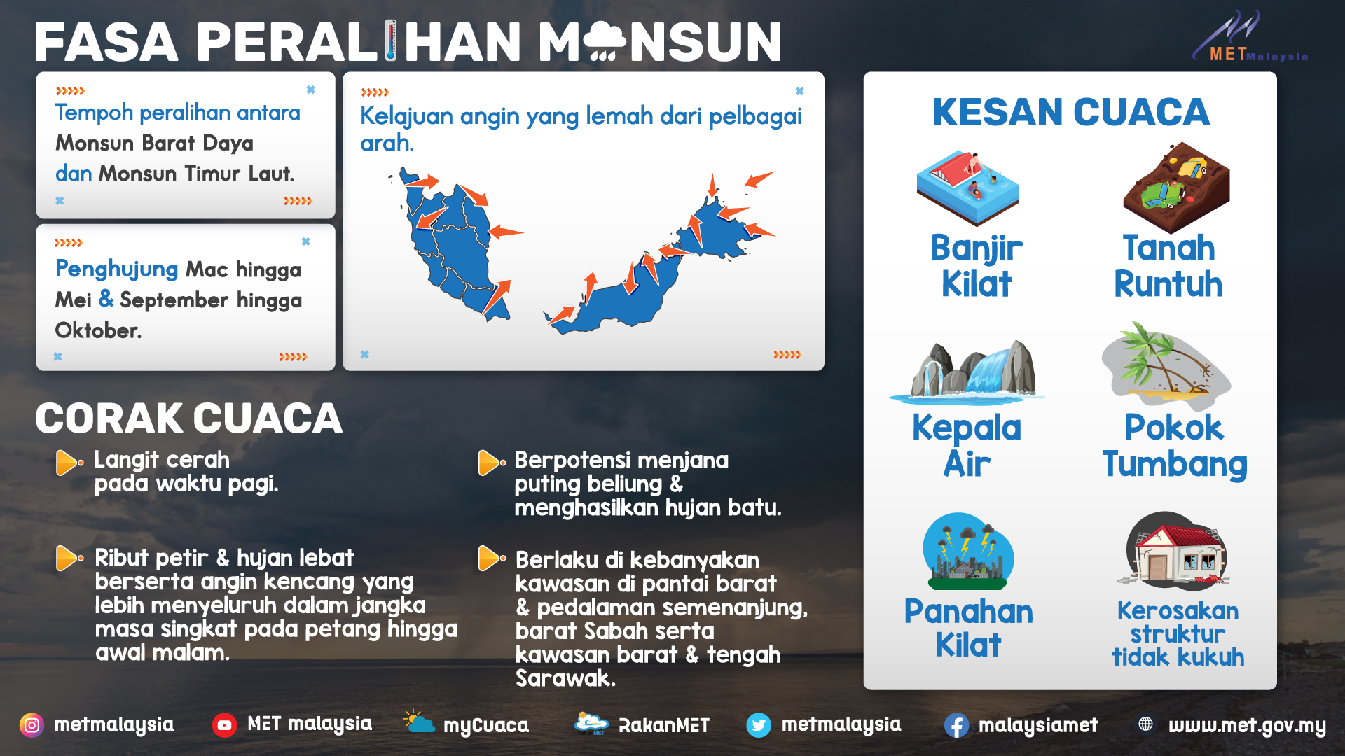
During the inter-monsoon phase, the wind is light and variable. In the morning, the sky is usually clear and this has helped the formation of thunderstorms in the afternoon. In the west coast states of Peninsular Malaysia, thunderstorms produce maximum average monthly rainfall during both monsoon transition seasons. These bad weather advisories and warnings will be disseminated through website, mass media, social media and mobile apps (myCuaca).
Before the monsoon season
a) Always listen to radio, television or social media broadcast for warnings of strong winds and rough seas.
b) Make sure there is enough water and non-perishable food supplies.
c) Clear drains, gutters and rain gutters from blockages.
During the monsoon
a) Stay on solid ground. Stay away from fast flowing drains, rivers and flooded areas.
b) Do not drive into flooded areas. Avoid crossing unstable bridges and roads that are always flooded.
c) Follow the instructions of your local disaster management authorities.
d) Be prepare to move it directed, especially for those living near coastal areas, nearby rivers or low-lying areas.
e) Make sure your vehicle is parked in a high place and all the other property is protected from loss and destruction due to floods.
f) Avoid going to sea by using small boats or ships.
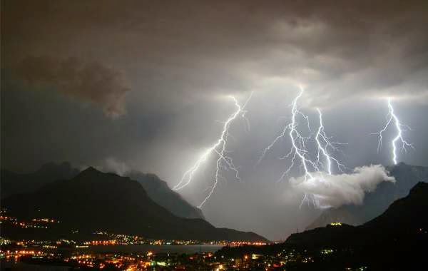
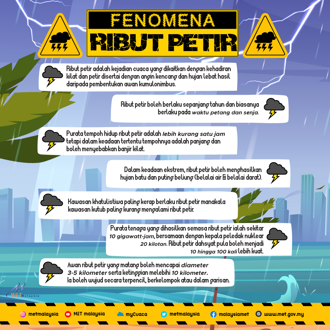
In Malaysia, thunderstorms are a common phenomenon that occurs throughout the year and usually occur in the evening and early evening. Although relatively small in size, all thunderstorms are dangerous. Every thunderstorm produces lightning that can threaten human life.
Heavy rain from thunderstorms can cause flash floods and landslides. Strong winds and hail associated with some thunderstorms are also dangerous.
A thunderstorm is defined by the World Meteorological Organization (WMO) as the occurrence of one or more sudden electrical discharges that produce flashes of light (lightning) and rumbling sounds (thunder).
a) Thunderstorm usually forms in unstable and humid atmospheric conditions.
b) Cumulus clouds form when warm, moist air rises from the earth's surface to higher altitudes and condenses.
c) It develops laterally and vertically into a large dense cloud called a cumulonimbus cloud, with strong turbulence within and a strong outflow beneath.
d) Mature thunderstorm clouds often have a cellular structure with a diameter of 3 to 5 kilometres and a height of more than 10 kilometres. They can exist individually, in groups, or in lines.
e) The average lifespan of a thunderstorm is between 15 and 30 minutes but certain conditions, this period is much longer.
Thunderstorms have the potential to produce hail, heavy rain, lightning and strikes and gusty winds. Some very bad weather conditions can occur when a group of thunderstorms hits an area for a long period of time.
Downburst is a term used to describe the rapid descent of air in a small area under a thunderstorm. The resulting strong winds can reach such high speeds that can cause significant destruction along their path and are very dangerous to flight operations.
Fluctuating air in a thunderstorm cloud results in the separation of positive and negative charges. Lightning is a discharge that occurs when the electrical charge difference between the earth's surface and the atmosphere is large enough to overcome the insulating effect of air. Lightning can occur either within the cloud, from cloud to cloud, or between the cloud and the earth's surface. Lightning often strikes outside the heavy rain area and can occur as far as 10 miles away from the rain area.
The air near the area struck by lightning heats up and reaches temperatures in excess of 27,000°C - hotter than the surface of the sun. The rapid heating and cooling of the air near the area struck by lightning creates a shock wave that produces thunder. Lightning can cause damage to installed electrical equipment and can start a fire. Most deaths and injuries from lightning occur to those outside buildings.
Thunderstorms can occur throughout the year but are more frequent during the inter-monsoon period from April to May and from October to November. On land, thunderstorms usually occur in the evening and dusk while in the ocean, they often occur at night. In Malaysia, Subang recorded the highest number of thunderstorms followed by Bayan Lepas and Kluang.
Before the Thunderstorm
a) Check the weather forecast before going out long periods.
b) Look for any signs of an approaching storms if any.
c) Postpone any outdoor activities if thunderstorms are expectedThunder.
During the Thunderstorm
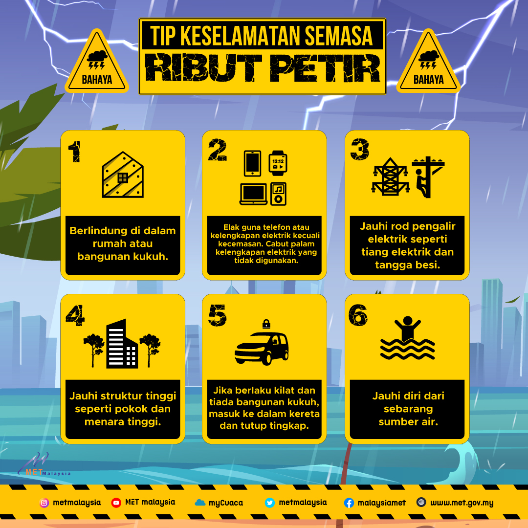
a) Get inside a strong building or car. Do not shelter in a small place or under an isolated tree.
b) If there is lightning and there is no secure shelter, get in the car and close the windows.
c) Get out of the boat and away from water.
d) Telephone lines and metal pipes can conduct electricity. Avoid using the phone or any electrical equipment. Use the phone only in emergencies. Unplug unused electrical equipment.
e) Do not shower.
f) Close the air conditioner. Lightning power surges can overload the compressor.
g) If driving on highways and overpasses, be aware of strong winds.
h) Move to higher ground if flash flooding is expected.
If trap outside the building and there is no shelter
a) Take shelter in low, non-flooded area away from trees, fences and poles.
b) If in the forested area, take shelter under a lower tree.
c) If it is found that our skin is irritated or our hair stand up, squat down on the ground. Place hands on knees with head in between knees. Make the body as small as possible and reduce it from touching the ground.
d) If you are boating or swimming, return to the to land and seek shelter immediately.
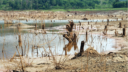
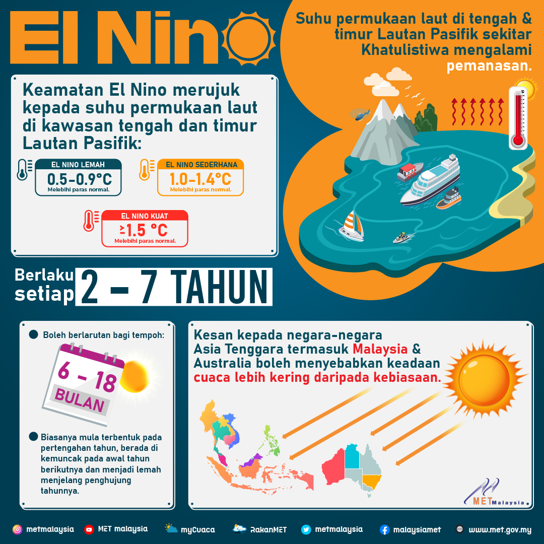
Every two to seven years, warm ocean currents replace the normally cool ocean currents off the west coast of Peru, South America. This ocean phenomenon is called El Niño. This ocean warming has been found to occur over a wider area covering the central and eastern Pacific and is associated with significant unusual weather events in certain parts of the world such as severe floods and prolonged droughts. In Southeast Asia, Indonesia and Australia, the weather conditions are drier than normal while in the central and eastern Pacific near the equator they usually experience humid conditions.
Typically, El Niño lasts for 6 to 18 months. It usually forms in the middle of the year, peaks at the end of the year and weakens towards the beginning of the following year. El Niños of the same intensity do not necessarily produce the same climate patterns.
During El Niño, warmer sea surface water in the central and eastern Equatorial Pacific Ocean supplies additional heat and moisture to the overlying atmosphere. This induces strong updrafts and thus lowers the surface pressure within the updraft area. The moist air that rises condenses and forms a large area of thunderstorms and heavy rain in the area. In the western part of the Pacific including Malaysia, atmospheric pressure increases, causing relatively dry weather.
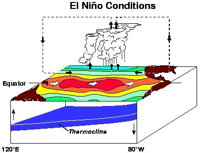
During normal (neutral) conditions, atmospheric surface pressure in the western Pacific is usually low while in the central and eastern Pacific it is high. In this situation, generally the condition of the western Pacific region is humid while the central and eastern Pacific is dry.
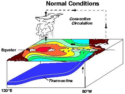
This alternating atmospheric surface pressure pattern in the tropical Pacific Ocean as the oceanic condition changes from El-Niño to neutral and vice versa is called the Southern Oscillation. This coupling relationship between the atmosphere and the ocean during El Niño event is known as El Niño-Southern Oscillation (ENSO).
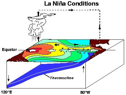
At times, though not always, sea surface temperatures in the central and eastern Pacific Ocean are lower than normal. This phenomenon is called La Niña, a condition opposite to El Niño. In this situation, the surface atmospheric pressure in the western equatorial Pacific region decreases, causing more active cloud formation and heavy rain.
During La Niña conditions, atmospheric surface pressure increases in the central and eastern Pacific while surface pressure decreases in the western Pacific. La Niña conditions are also known as the cold phase of ENSO.
The basic parameters used to monitor El Niño and the atmospheric response include sea surface temperature in the equatorial Pacific Ocean, temperature below the ocean surface up to a depth of 150 meters, cloud conditions and unusual rainfall patterns in the Pacific Ocean.
Because atmospheric pressure and sea temperature are closely related, an atmospheric index called the Southern Oscillation Index (SOI) is also used to measure the atmospheric response to this phenomenon. This index is calculated from the difference in monthly atmospheric pressure fluctuations between Tahiti (representing the eastern Pacific) and Darwin (representing the western Pacific). If there is a significant negative SOI value, persisting for at least six months, we are experiencing an El Niño condition. The greater the negative value, the higher the intensity of El Niño. Conversely, high positive SOI values indicate La Niña conditions. A strong El Niño/La Niña is usually represented by an SOI of 1.5 (negative for El Niño and positive for La Niña) or more and prolonged while moderate conditions are represented by an index ranging between 0.8 and 1.5. A weak El Niño condition is between 0.4 and 0.8.
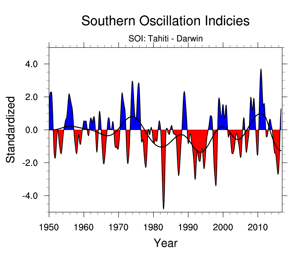
(Sumber: Climate & Global Dynamic, NCAR)
Another definition of El Niño and La Niña conditions used by the National Oceanic and Atmospheric Administration (NOAA) is defined as the change in ocean surface temperature in the Niño 3.4 region (5°N-5°S, 120°W-170°W), referred to as Oceanic Niño Index (ONI). Using this index, El Niño is characterized by an ONI of +0.5°C or more while La Niña is -0.5°C or less. The condition to classify an El Niño/ La Niña episode is that the ONI value must be equal to or exceed the threshold value (+/-0.5°C) continuously for at least five months.
The Climate Prediction Center, National Oceanic and Atmospheric Administration (CPC, NOAA) has listed the episodes as El Niño and La Nina years based on the Oceanic Niño Index as follows:
El Nino | La Nina | |||||||
Weak | Moderate | Strong | Very Strong | Weak | Moderate | Strong | ||
1951-52 1952-53 1953-54 1958-59 1968-69 1969-70 1976-77 1977-78 | 1979-80 1994-95 2004-05 2006-07
| 1963-64 1986-87 1987-88 1991-92 2002-03 2009-10 2014-15 2018-19 | 1957-58 1965-66 1972-73 | 1982-83 1997-98 2015-16 | 1950-51 1954-55 1964-65 1967-68 1971-72 1974-75 1983-84 1984-85 | 1995-96 2000-01 2011-12 | 1955-56 1970-71 1998-99 1999-00 2007-08 2010-11 2020-21 2021-22 | 1973-74 1975-76 1988-89 |
In the Tropics, cloudy conditions and thunderstorm activities shift from the western Pacific to the central and eastern Pacific, causing unusually dry conditions in Malaysia, Indonesia, the Philippines and northern Australia during El Niño. Hotter and drier weather also occurs in southeast Africa, India and northern Brazil. Wetter weather occurs along the west coast of tropical South America and the gulf coast of North America as shown in the diagram below.
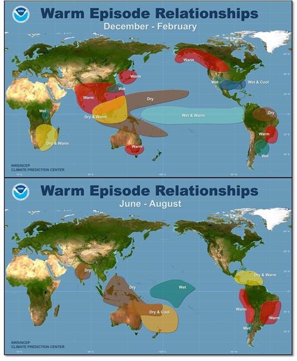
With the presence of a moderate or strong El Niño, rainfall in Sabah and Sarawak will be far below average during the Southwest monsoon (June-August) and Northeast monsoon (November-February), on the other hand in Peninsular Malaysia the rainfall is below average level only during Southwest monsoon (June-August).
A weak El Niño condition is identified to have a minimal impact on rainfall in Malaysia. Furthermore, below and above average rainfall can also occur in non-El Niño/La Niña years.
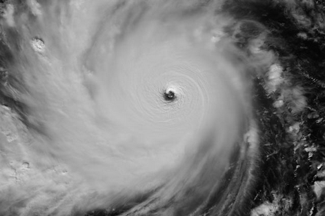
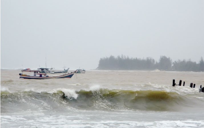
Tropical cyclones are violent storms that rotate and have a diameter of several hundred kilometres that form in tropical waters. When seen by satellite, it looks like a strong, tight coil system with cloud clusters spiralling outward. For a mature tropical cyclone, there is a central area of relatively calm air with few clouds. This area is known as the eye of the tropical cyclone.
The necessary conditions for this storm are the initial existence of a weather disturbance, warm and humid tropical seas and weak winds. If these favorable conditions exist over a long enough period of time, they can combine to produce strong winds and waves, heavy rains and floods.
Hurricanes, cyclones and typhoons are similar weather phenomena. The use of different names refers to storms in different oceans. In the Atlantic Ocean and Northeast Pacific Ocean, it is called a "hurricane". The same type of weather disturbance that occurs in the Northwest Pacific Ocean is called a "typhoon" while the name "cyclone" is used for weather disturbances that occur in the South Pacific Ocean and the Indian Ocean.
Tropical cyclone is a generic term describing an eddy, organized cloud system and thunderstorm that originates in tropical or sub-tropical waters and has a closed coil at low level. When the tropical cyclone reaches a maximum speed of 118 km/h or more continuously, it will be classified as a hurricane, typhoon or cyclone based on the place where the storm originates.
Tropical cyclones are classified as the followings:
a) Tropical DepressionA system consisting of rotating clouds and thunderstorms with a maximum sustained wind speed of 61 km/h or less.
b) Tropical StormA rotating strong thunderstorm system with sustained maximum wind speeds of between 62 - 117 kmph.
c) TyphoonA strong and distinct tropical weather system rotates with maximum sustained wind speeds of 118 km/h or more.
Tropical cyclones form in areas of the ocean where the surface temperature is 26 °C or more. In the Asian region, tropical cyclones are often known as typhoons and usually occur during summer in the Northern Hemisphere where the temperature in the Pacific Ocean is warm and suitable for convective activity. A low pressure system that forms in a warm tropical ocean area moves westward and develops from a tropical depression to a tropical storm and finally a mature hurricane.
The cyclone that forms gathers heat and energy through contact with warm ocean water. The heat and moisture produced by the evaporation of the sea surface powers it like a giant heat engine. The formation of clusters of thunderstorms allows the air to become warmer and rise higher in the atmosphere.
The formation of a tropical cyclone requires the following suitable environmental conditions:
Warm sea waters (at least 26.5 °C) with a depth of at least 50 meters. Warm waters are needed to be the catalyst in the formation of tropical cyclones.
An atmosphere that cools quickly enough with height creates an unstable condition that promotes the convection of moist air. This is a thunderstorm process that allows heat stored in ocean waters to be released for the development of tropical cyclones.
The moist layer is close to the middle layer of the Troposphere (5 km). The dry middle layer is not conducive to allowing the development of widespread thunderstorm activity.
Located at a minimum distance of at least 500 km from the Equator. The Coriolis force is required in the formation of low pressure disturbance systems and supports the development of such systems.
An existing near-surface disturbance forms with sufficient collisions and vortices. Tropical cyclones cannot be generated spontaneously. For it to form requires a small planned weak system with sufficient inward rotation.
Low vertical wind shear (less than 20 Knots) between the surface and the upper Troposphere. Vertical wind shear is the magnitude of wind change with height. Large vertical wind shear disrupts the growth of newly formed tropical cyclones.
The eye of a hurricane with a diameter of between 30 - 100 kilometres is the centre of the low pressure. The most intense (or violent) activity occurs in the area around the eye which is also called the wall of the eye. Here, the air rotates upwards and outwards with increased speed. Some of the air moves inward and sinks into the eye, forming a cloud-free region.
Typically, hurricanes begin to appear in the western North Pacific in early May. The number increases and reaches a maximum around September. Most typhoons form in the latitudes of 5 °N and 20 °N and longitudes of 130 °T and 170 °T. The typhoon's normal path is to move westward across the Philippines and then turn northeast-ward as it approaches the Asian mainland.
The countries that are members of the World Meteorological Organization's Typhoon Committee among the countries in the Northwest Pacific Ocean including Malaysia contribute to the name of the typhoon that is formed. Regional Specialized Meteorological Center Tokyo, Japan is responsible for naming typhoons based on a list of names supplied by member countries.
Typhoon is one of the most terrible and destructive natural disasters. His long journey and long life make his presence terrible and bring destruction.
Some of the hurricane-related threats are:
a) Storm DrainA storm trough is a large dome of water, 50 to 100 miles wide that sweeps along the coast near where a hurricane meets land. Strong typhoons and shallow waters will produce higher currents. Storm surges are the biggest threat to life and property especially along the coast.
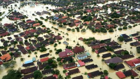
b) Heavy Rain Torrential and extensive rains can cause devastating floods.
c) Strong WindHurricane force winds can destroy unsound buildings and structures. Debris flying in the hurricane. Strong winds can knock down trees and snap power lines that can cause major disruptions.
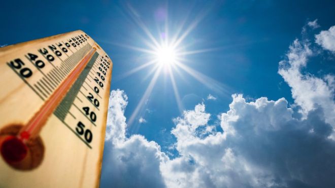
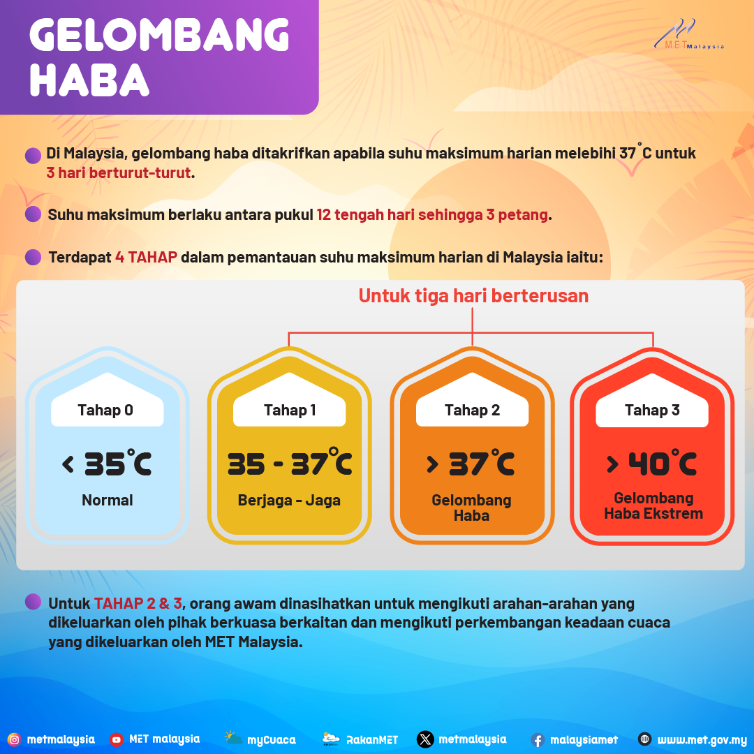
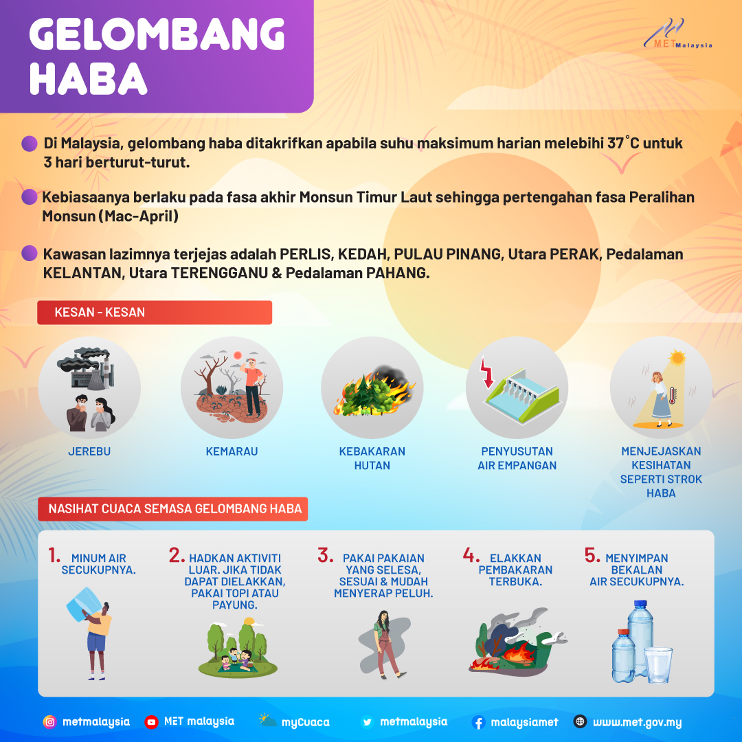
A heat wave is a period of unusually high temperatures, exceeding the daily average maximum temperature and relatively hot weather conditions, usually lasting up to several days or several weeks. There are several significant implications caused by heat waves including the use of electricity, water resources, agriculture and public health and in extreme cases, can cause death. Each country has a different threshold value to determine a heat wave event which is based on long-term maximum daily temperature and also other climate data. In Malaysia, a heat wave is defined when the maximum daily temperature exceeds 37°C for three consecutive days. There are four stages in the heat wave monitoring involving daily maximum temperature in Malaysia developed by MET Malaysia as follows:
Stage/Category
|
Status |
Criteria |
0
|
Normal |
Daily maximum temperature is less than 35.0oC
|
1
|
Careful |
Daily maximum temperature 35.0oC to 37.0oC for at least three (3) consecutive days
|
2 |
Heat Wave
|
Daily maximum temperature above 37.0oC to 40.0oC for at least three (3) consecutive days
|
3
|
Extreme Heat Wave |
Daily maximum temperature above 40.0oC for at least three (3) consecutive days
|
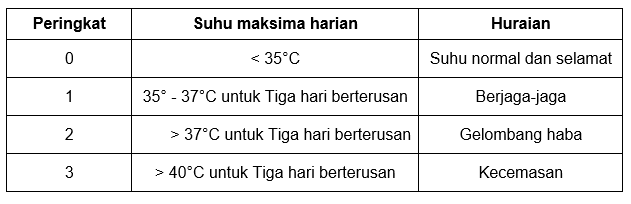
For the Level 2 and Level 3, the public should heed the advice issued by the relevant authorities and follows the weather updates issued by MET Malaysia.
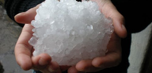
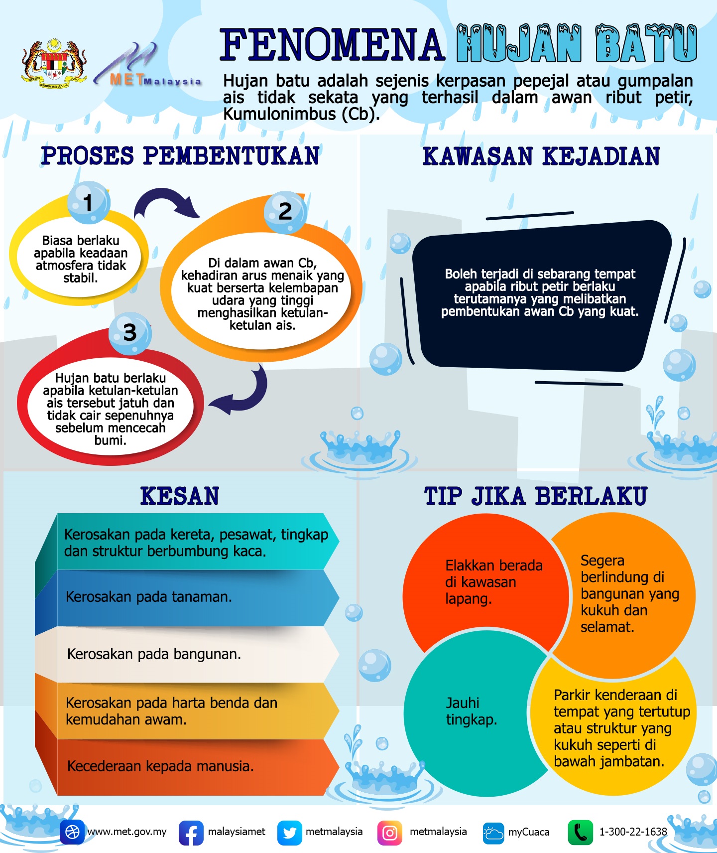
Hail is a form of solid precipitation. Round or irregular lumps of ice called hail, produced by thunderstorm clouds (Cumulonimbus). Within these thunderstorm clouds, there are strong updrafts and downdrafts. At a certain height, the temperature is below freezing and water condenses on dust or other particles known as condensation nuclei. The very cold water molecules continue to condense on the condensation nuclei and freeze, producing a lump of ice that acts as the center of the water rock. Chunks of rock water will float in thunderstorm clouds due to updrafts but will fall below freezing due to gravitational attraction. At that time, ice particles collide with raindrops and other ice particles and collect to form a layer of water or aggregate together to form an icy and thorn-shaped blob. Eventually, it gets caught in the updraft and passes through the freezing layer, whereupon this new layer freezes. The water cycled up and down in the thunderstorm cloud until one of the following two conditions occurred: The water experienced a downward current that pushed the water to the Earth's surface or the water grew to a size where it was too large for the updraft overcome the pull of gravity, until it falls to the surface of the earth. Most thunderstorms contain hail but not all thunderstorms produce hail. The temperature at the top of a thunderstorm is below freezing which causes ice to form but sometimes ice melts before it falls to the earth's surface. Hailstone rain has been reported in several places in Selangor State and WP Kuala Lumpur.
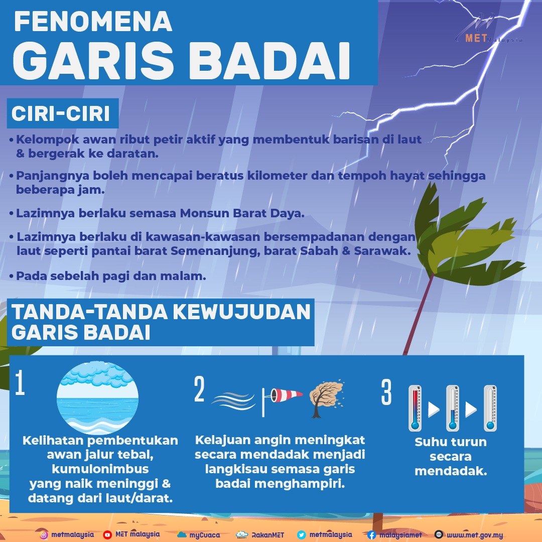
A line of storms is a term used to describe a moving line of thunderstorms. They can be hundreds of kilometres long and have a lifespan of several hours which is considered longer than the thunderstorm component. A line of storms produces severe and widespread sleet and heavy rain compared to individual thunderstorms.
Storm lines are often seen during the Southwest monsoon along the west coast of Peninsular Malaysia and the coastal areas of East Malaysia facing the South China Sea.
If you live in the west coast of peninsular Malaysia
You can observe a characteristic cloud formation, which are thick bands of cumulonimbus clouds that rise and come from the sea.
Wind speed increase sharply to gusts as a storm line approaches.
The temperature drops suddenly.
The track of the storm line is often accompanied by thunder, lightning and heavy rain.
When it reaches land, the latent heat of condensation is lost and it also dissipates quickly.
The intensity of the rainfall decreased and the situation returned to normal about an hour later.
Storm lines usually occur during the predawn and early morning hours and are most common between April and November. However, storm lines can sometimes form in the evening and move inland along with prevailing winds.
Sumatras is a unique phenomenon on the west coast of Peninsular Malaysia.
Its formation is due to the location of the Sumatra Islands in the west and Peninsular Malaysia in the east, separated by the narrow Malacca Strait.
During the Southwest Monsoon, the Southwest wind blows across the mountain range in Sumatra and produces mountain waves on the lee side and causes atmospheric instability.
Sea water in the Strait of Malacca which is relatively warm provides a source of moisture in the formation of waves.
In an atmosphere with high instability, thunderclouds form in that place and merge into squall lines.
When it reaches land, the latent heat of condensation is lost and it also dissipates quickly.
The storm line moves towards the Northeast driven by Southwest winds to the West coast of Peninsular Malaysia
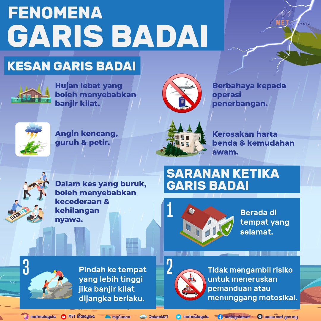
The Storm Line marks an area of extreme instability and violent upheaval. A thunderstorm cell embedded in a storm can produce lightning, heavy rain that brings flash flooding, and strong winds. In bad cases, it can cause injury and loss of life in addition to property damage.
Hurricane Lines are dangerous to flight operations because:
Strong wind shear in clouds has caused many fatal crashes.
Downdrafts and updrafts in cloud are dangerous to light aircraft that are not equipped with sophisticated equipment to detect them.
Downbursts from cloud base can affect low-level flight especially during landing.
Due to high intensity rainfall, low-lying areas and areas with poor irrigation systems may experience flash flooding when the storm line hits.
At the end of 1996, flash floods hit Penang and Seberang Prai caused by a storm that formed in the north of the Straits of Malacca that moved quickly inland in the morning. This flood has caused a lot of damage to property and public facilities. The amount of rainfall is the highest ever recorded.
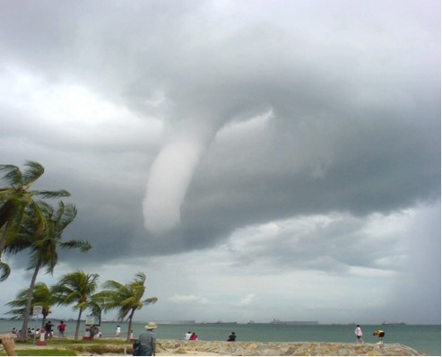
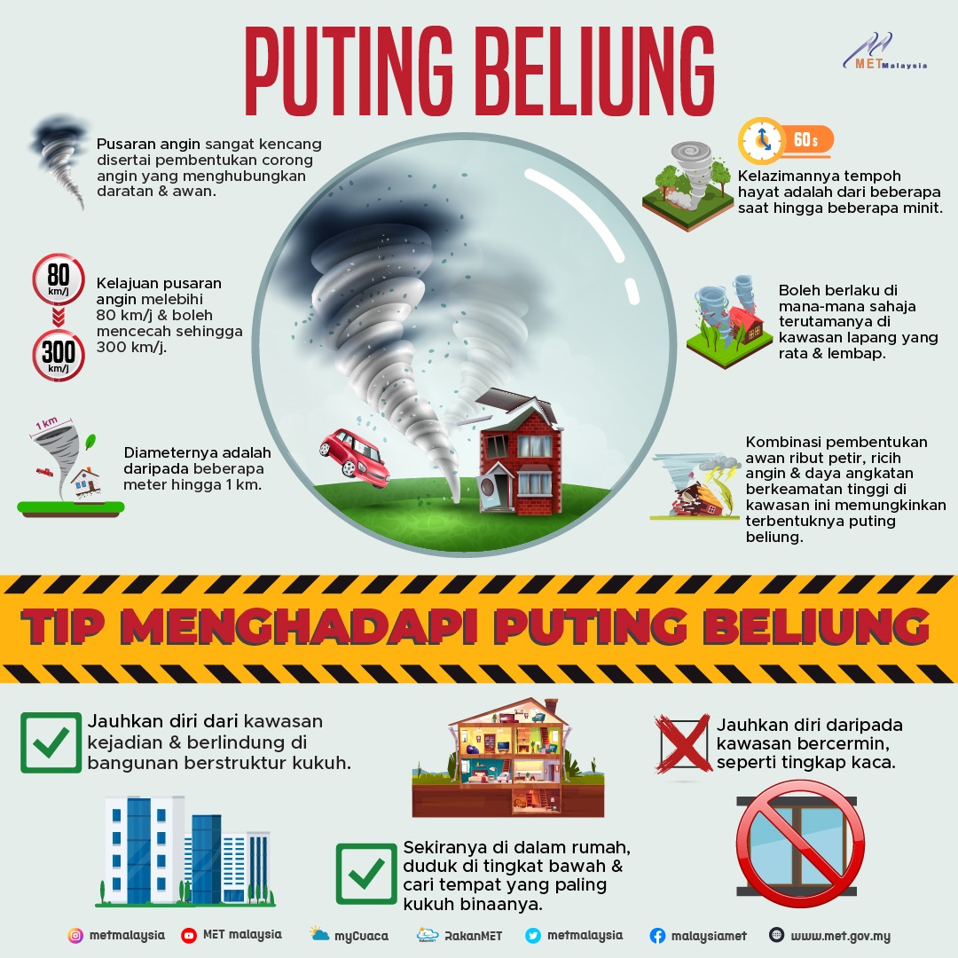
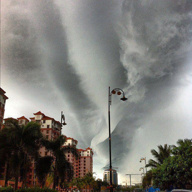
Generally, a water tornado is a type of tornado that occurs over water. It is a strong columnar eddy (usually looks like a funnel cloud) that occurs at the surface of the sea and mostly in Tropical and Sub-Tropical regions. It connects with towering cumulus clouds or cumulonimbus clouds during severe weather conditions such as thunderstorms. Most waterspouts do not suck in water and they are not as powerful as tornadoes in land areas. Water proboscis are small in size, have a short life of up to tens of minutes and weaken when heading to the beach.
The small column or funnel is actually water droplets in the air vortex. As the air swirls and rises, the warm air cools and condensation of water vapor occurs, forming the visible funnel cloud. The occurrence of water snails has been reported in Malaysian waters such as Penang, Kedah, Perak, Sarawak, Sabah and WP Labuan.
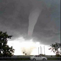
Tornadoes and tropical cyclones are two weather phenomena that differ in terms of size, lifespan and the place where they form. Tornadoes have a size on the scale of hundreds of meters, a life span of a few minutes and form on land while tropical cyclones have a size of up to hundreds of kilometres, a life span of several days and form on the sea.
A tornado is a column of strong winds from a thunderstorm cloud to the earth's surface. Tornadoes form from unusually violent thunderstorms characterized by the presence of a meso-cyclone; a continuous and deep vertical upward vortex. Thunderstorms of this type can occur anywhere in the world if the initial conditions are suitable such as very unstable and humid atmospheric conditions. A funnel cloud is a funnel-shaped cloud of condensed water droplets, related to the vortex column and begins to form from the base of the Cumulonimbus cloud or tower-type Cumulus cloud and does not touch the ground or water surface. If the funnel cloud touches the ground, then it produces a tornado.
The damage from a tornado is caused by the strong winds it produces. Most tornadoes produce wind speeds of less than 180 kmph and in extreme cases, wind speeds can reach 480 kmph. High wind speeds can blow away vehicles, destroy houses and other effects caused by flying debris. Forecasting the occurrence and movement of tornadoes is difficult due to their small size and short lifespan. In Malaysia, a tornado was recorded in Kedah between October and November 2014.
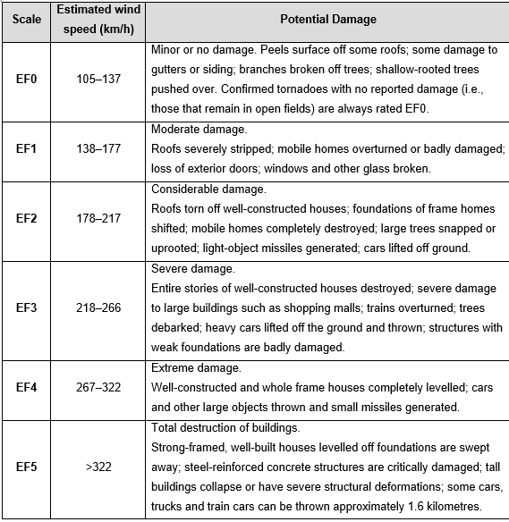
Tornadoes are categorized using the enhanced Fujita Tornado Intensity Scale which is based on damage. The tornado scale is named after its creator, Ted Fujita, who developed the original scale in 1971. Both the original and improved scales categorize tornadoes based on strength and extent. From 1971 to 2007, the Fujita Scale was used and an upgrade of the Fujita Scale was used thereafter. The increase in Fujita Scale is as follows:
Enhanced Fujita Scale (Implemented February 2007) | ||
Scale | Wind Speed (km/h) | Potential Damage |
EF0 |
105-137 | Minor or No Damage Shingles or parts of roof peeled off; damage to gutters/siding; branches broken off; shallow-rooted trees topples |
EF1 |
138-177 | Moderate Damage More significant roof damage; windows broken; exterior doors damaged or lost; mobile homes badly damage or overturned |
EF2 |
178-217 | Considerable Damage Roofs torn off well-constructed homes; homes shifted off their foundation; mobile homes completely destroyed; large trees snapped or uprooted; cars may be tossed |
EF3 |
218-266 | Severe Damage Entire stories of well-constructed homes destroyed; significant damage to large building; homes with weak foundations may be blown away; trees begin to lose bark |
EF4 |
267-322 | Extreme Damage Well-constructed homes levelled; cars thrown significant distances; top story exterior walls of masonry buildings likely collapse |
EF5 |
>322 | Incredible Damage Well-constructed homes swept away; steel-reinforced concrete structures critically damaged; high-rise buildings sustain severe structural damage; trees usually completely debarked; stripped of branches, and snapped |